

 An ATSB investigation into the fatal crash of a Mooney M20J in Dorrigo National Park near Coffs Harbour has ruled a series of decisions by the pilot and air traffic control led to the accident.
Father Jeffrey Hills, 59, was piloting the aircraft with his son, Matthew, 25, on board when it was found to have crashed into heavily wooded and steep terrain on 20 September 2019.
In particular, investigators found the pilot didn’t have a valid licence to undertake the flight but that “limited information” provided by air traffic control influenced the pilot’s decision to descend into a “hazardous area”.
ATSB chief commissioner Greg Hood urged all current controllers and private VFR pilots to read the final report, which you can access here.
The controlled flight into terrain accident of a Mooney light aircraft near Coffs Harbour in which the pilot and passenger lost their lives highlights both the importance of pre-flight planning and pilot proficiency checks, and the influence air traffic control can have on pilot decision-making, a new ATSB investigation details.
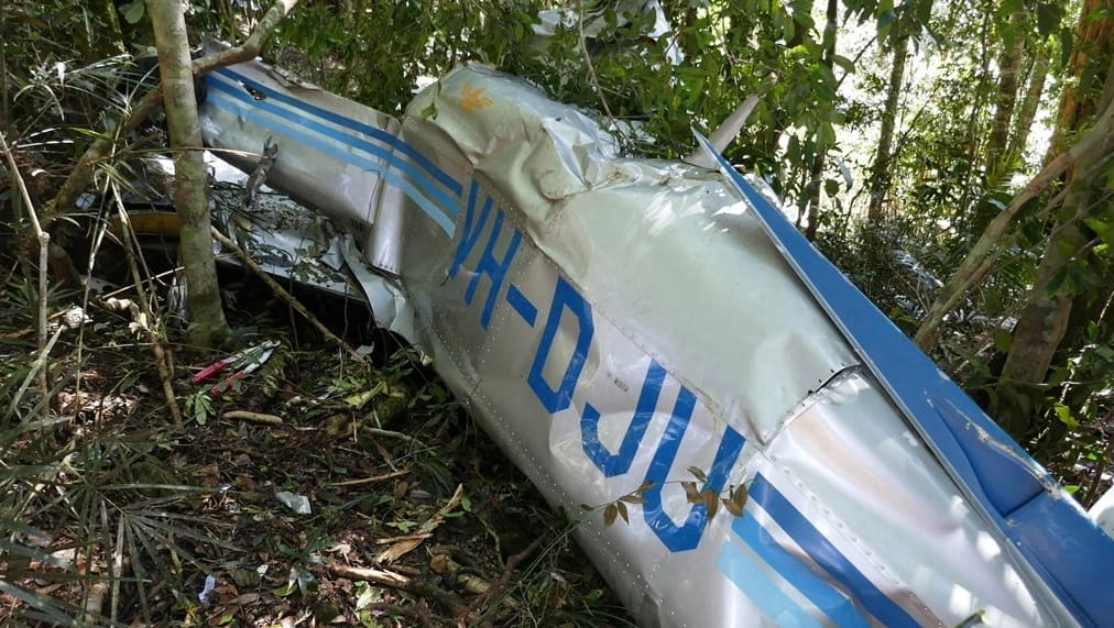
The Mooney M20J four-seat aircraft, VH-DJU, was being operated on a private flight under visual flight rules from Murwillumbah to Taree on the morning of 20 September 2019.
About 45 nautical miles north of Coffs Harbour at 7:17am and at an altitude of 6,500 feet the pilot requested air traffic control permission to enter and transit Class C controlled airspace, which lay in the direct track to Taree.
A trainee controller working under supervision (operating from the Brisbane Centre air traffic control facility), having made an assessment of their workload, advised that a clearance was not available and provided the pilot the option to request a clearance to transit through the lower Class D airspace surrounding Coffs Harbour Airport.

The pilot subsequently contacted the controller in the Coffs Harbour control tower responsible for managing the Class D airspace, who advised that due to extensive cloud cover, a visual transit would only be possible at an altitude not above 1,000 feet. The pilot responded that the aircraft would descend to ‘not above 1,000 feet’.
The Mooney then continued on a direct track to Taree and at 7:24am the pilot reported that the aircraft was operating outside controlled airspace in clear conditions at 4,100 feet and would remain on that track.
Recorded air traffic control surveillance data (the aircraft was equipped with an ADS-B transponder) showed that the aircraft was then climbed to 4,500 feet before a descent was commenced, at 7:32am, in the vicinity of high terrain. The aircraft’s last recorded position was descending through an altitude of 3,564 feet at a ground speed of 165 knots.
When the aircraft did not arrive at Taree as expected a search was initiated. The aircraft was subsequently found to have impacted heavily wooded, steep terrain in the Dorrigo National Park at an elevation of 2,920 feet, about 26 kilometres west of Coffs Harbour Airport. Both the pilot and passenger were fatally injured.
“Information provided by air traffic control likely resulted in the pilot deciding to descend the aircraft from 6,500 feet instead of other available safe options, such as proceeding around the Class C airspace at or above 6,500 feet, diverting, or descending to the north of Grafton to proceed coastal beneath the cloud layers south to Taree,” said Hood.
“The ATSB also found that the pilot was not carrying suitable navigation equipment – the pilot was likely using a handheld GPS unit while air navigation charts for the area were found stowed in a flight bag – and had most likely not obtained the required weather forecasts. These factors reduced the pilot’s ability to manage the flight path changes and identify the high terrain.
“This led to the aircraft being descended toward the high terrain in visibility conditions below that required for visual flight, resulting in controlled flight into terrain.”
The pilot had also not completed the required flight reviews or proficiency checks, Hood said. As a consequence, the ATSB found the pilot did not hold a valid licence to undertake the flight, and their knowledge and skills required for effective flight management and decision‑making had likely deteriorated.
“This tragic accident emphasises to pilots the importance of flight preparation and of ensuring they have completed all required training and checks,” said Hood.
“Thorough flight planning and flight reviews and proficiency checks allow pilots to develop and maintain the necessary skills to manage challenges in flight, such as inclement weather or inadvertent entry into non-visual conditions.
“Further, confirming that appropriate operational information is obtained and readily available ensures that a pilot is well prepared to anticipate in‑flight complications and successfully manage unforeseen challenges.”
The investigation also found that the pilot was not provided clearance to transit Class C airspace due to the trainee controller’s conservative assessment of their workload, although there was no conflicting traffic, meteorological factors or limiting air traffic control instructions or procedures that would have precluded providing the clearance.
The trainee’s supervisor accepted the assessment as an alternate option – transiting through Coffs Harbour Class D airspace – was provided to the pilot.
“The pilot was not provided with a clearance to transit Class C airspace despite there being no limiting meteorological factors,” Hood said. “Instead, the Class C controller provided the option to seek a clearance at a lower altitude with an increased risk of encountering poor weather.
“Further, the limited information provided by the Class D controller to enter that airspace probably led to the pilot’s decision to descend into a hazardous area instead of opting for other available safe options.”
Since the accident, Airservices Australia has implemented a number of proactive safety actions.


Alan
says:A late comment but as a private IFR rated pilot and having flown similar routes and in that general Coffs Harbour area, the best option by the sound would have been to descend visually and proceed coastal not above 1,000′ weather and cloud permitting.
The land just west of Coffs Harbour rises very steeply to nearly 4,000′ in parts so the LSALT is 6,000′, certainly no place for a VFR flight in bad weather.