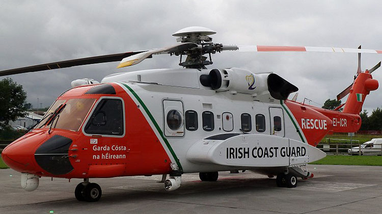
Ireland’s Air Accident Investigation Unit (AAIU) has used recovered cockpit voice and flight recorder data to determine an Irish Coast Guard Sikorsky S-92 flew into terrain while making an approach to refuel when it fatally crashed on March 14.
The AAIU’s preliminary report, released on April 13, said in the final seconds of its controlled flight theCHC Ireland-operated helicopter, EI-ICR “Rescue 116”, pitched up rapidly in an attempt to avoid hitting the western end of Black Rock Island, about 17km off Ireland’s west coast.
The helicopter struck the island in a nose high attitude before departing from controlled flight.
The S-92’s radar altimeter provided a callout of “ALTITUDE, ALTITUDE” 26 seconds prior to the initial impact which the pilot-in-command identified the aural alert as being “just a small little island …” below the helicopter.
Following the initial impact, the data indicated the helicopter climbed while experiencing large changes in pitch, roll and yaw angles.
The report said the flightcrew had programmed in a GPS approach route into their flight management system for a landing at Blacksod Bay, Mayo, on the mainland and had selected the automatic flight control system’s search-and-rescue (SAR) ‘Approach 1’ mode, which automatically descends the helicopter down to 200ft above the water at an airspeed of 80kt.
At the time of the accident, Irish meteorological service Met Éireann estimated the visibility as being two to three kilometres in mist and drizzle with an overcast ceiling at 300 to 400ft.
Despite being equipped with a Honeywell Mk XXII EGPWS with modified software for SAR profiles, the manufacturer of the system informed the AAIU that Black Rock Island was not in the terrain database for the EGPWS.

Additionally, the lighthouse atop the island was also not in the system’s obstacle database.
The Commissioners of Irish Lights confirmed the lighthouse on Black Rock Island for the night of the accident was operational and functioning correctly.
Honeywell told investigators that the EGPWS was “a situational awareness tool” and it was “not to be used for navigation”.
The AAIU issued an Interim Safety Recommendation suggesting CHC Ireland review and re-evaluate all of its route guides in use by its SAR helicopters in Ireland with a view to enhance the information provided on obstacle heights and positions, terrain clearance, vertical profile, the positions of waypoints in relation to obstacles and EGPWS database terrain and obstacle limitations.
In its statement released on the same day as the preliminary report, CHC Ireland said a review of all route guides in use was well underway as part of its internal action, adding: “It is worth stressing that this is an initial report and it does not identify the root cause of this tragic accident.”
The investigation into determining the full causes of the accident continues.